+1.585.321.5800
Atmospheric model
Atmospheric conditions have an effect on the propagation of GNSS signals, and as such can be an error source. GSG allows for these effects to be simulated, by applying tropospheric and ionospheric models to a scenario.
To configure these models, navigate to:
Select > [Select Scenario] > Configure scenario, View 2/3 > Advanced > Atmospheric model.
The GSG unit comes with built-in support for a model of the ionosphere. By default the used model is a reverse model of the model described in IS-GPS-200D, Section 20.3.3.5.2.5, called Klobuchar.
The a0-3 and b0-3 parameters set in the default model are set by the used navigation data files. When set to Off, no delays caused by the ionosphere are used in the simulation.
Under normal testing conditions, the Klobuchar ionosphere model should be used.
Note: The GSG also supports simulation of ionosphere delays using files in the IONEX format.
A number of tropospheric models are supported by the device. These are:
- Saastamoinen model. The model is based on Saastamoinen, J., 'Atmospheric Correction for the Troposphere and Stratosphere in Radio Ranging of Satellites,' The Use of Artificial Satellites for Geodesy, Geophysics Monograph Series, Vol. 15., American Geophysical Union, 1972
- Black model. The model is based on Black H., ‘An Easily Implemented Algorithm for the Tropospheric Range Correction’, JOURNAL OF GEOPHYSICAL RESEARCH, 1978
- Goad&Goodman, a tropospheric model based on Goad and Goodman(1974), "A Modified Hopfield Tropospheric Refraction Correction Model", 1974
- STANAG model. The model is based on NATO Standardization Agreement (STANAG) Doc. 4294, Appendix 6.
The tropospheric model can also be set to Off, and no tropospheric delays are used in simulation. Under normal testing conditions, one of the tropospheric model should be used.
The tropospheric model also allows for the temperature, pressure and humidity to be configured:
- Temperature: to be specified in degrees Celsius
- Atmospheric pressure: in millibars
- Humidity: relative humidity in percent.
The graph below illustrates the delays for the different models available, using default values for environmental conditions.
Note that the tropospheric delay added to satellites with low elevation angles are ‘capped’ at a maximum value. The capping delay value and the elevation angle are a function of the model used.
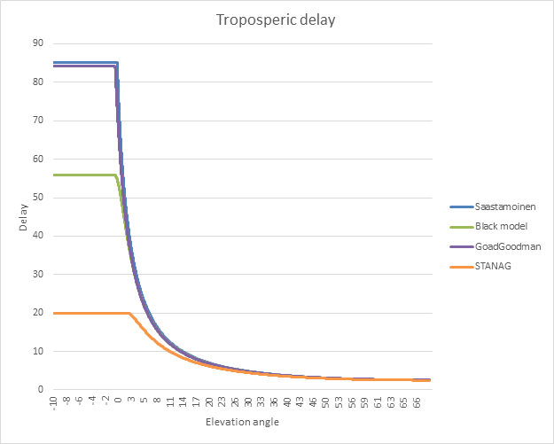
Tropospheric delay vs. elevation angle