+1.585.321.5800
Performing a GNSS Receiver Survey
Note: This topic only applies to stationary applications – in Mobile receiver mode NO surveys will be carried out since the position is updated continuously.
When SecureSync's integrated GNSS receiver performs a survey, it tries to determine or verify its geographic position with high accuracy. An accurate geographic position is required to calculate a precise system time from the GNSS reference.
During a GNSS survey, the position will be iteratively recalculated while gradually increasing the position accuracy. A survey can take up to 33 minutes, but typically SecureSync will synchronize earlier, i.e. offer a valid Time and 1PPS reference, once it has obtained a sufficiently accurate preliminary position.
Note: If a system has been moved, in Standard receiver mode and Land Dynamics, receivers will automatically re-survey on reboot. In Standard mode and Stationary Dynamics, the unit will survey only once, and will not re-survey on reboot.
Depending on the GNSS receiver model installed in your SecureSync, the default behavior is either:
- that the GNSS receiver detects if the SecureSync has been relocated, and hence will initiate a GNSS survey to determine the new position
- or that a power cycle, or a reboot will automatically initiate a GNSS survey.
- To reboot your unit, navigate to TOOLS > SYSTEM: Reboot/Halt.
- While a (re-)survey is crucially important if a SecureSync unit has been relocated, e.g. when commissioning a new unit, it is normally not required if a stationary unit is rebooted for other reasons. To turn off this functionality, see Setting GNSS Receiver Dynamics.
Note: Behavior (a.) applies to most Trimble® receiver types, while behavior (b.) applies to u-blox® receivers.
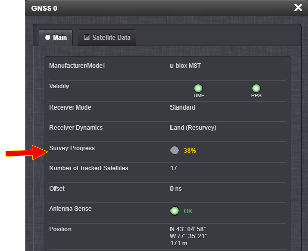
To see if SecureSync's GNSS receiver is performing a survey and if so, verify its progress:
- Navigate to INTERFACES > REFERENCES: GNSS 0.
- The survey status (ACQUIRING, COMPLETE, or progress in percent) is displayed under the line item Survey Progress.
Note: Once a survey has been initiated, the Survey Progress may not be displayed right away until the receiver has completed its initialization process.